Cover Photo: Atown Bikes (Keep Cyclin, LLC), via Instagram.
(AUBURN, CA) — As collisions and traffic fatalities involving motorists, pedestrians, and bicyclists continue to rise in the Auburn area, the City Council unanimously approved two long-term transportation planning documents: the Active Transportation Plan (ATP) and Comprehensive Safety Action Plan (CSAP).
The approval followed an extensive discussion on bicycle safety, roadway design, and the city’s long-term transportation priorities. It also comes weeks after the council declared May as “Bike Month.”
Presented by Robert Hananouchi of transportation consulting firm Fehr & Peers, the plans are intended to guide future investments in transportation infrastructure while strengthening Auburn’s competitiveness for state and federal transportation grants. Although the plans do not authorize immediate construction projects, officials described them as foundational policy documents that will shape the city’s approach to transportation safety over the coming decades.
Robert Hananouchi presenting the ATP and CSAP followed by public comment. Video Source: Auburn City Council via YouTube.
Public comment centered on how best to protect cyclists on Auburn's streets, particularly along major corridors such as Highway 49, Auburn-Folsom Road, and Lincoln Way. Several residents argued that current bicycle infrastructure is insufficient in high-traffic or high-speed areas and called for stronger physical separation between vehicles and cyclists.
Skyridge resident Alex Anderson criticized the effectiveness of painted bike lanes, arguing that striping alone does little to improve rider safety. “Paint is not protection,” Anderson said of Class 2 bike lanes, noting that lane markings in some locations are faded or frequently crossed by vehicles, particularly near right-turn lanes.
Other residents echoed similar concerns and urged the city to prioritize Class 4 protected bikeways—physically separated lanes using curbs, bollards, or landscaped barriers—over buffered or painted bike lanes.

“Paint is not protection” says Alexander Anderson of Class 2 bike lanes (pictured above). Image Source: Robert MacMahon
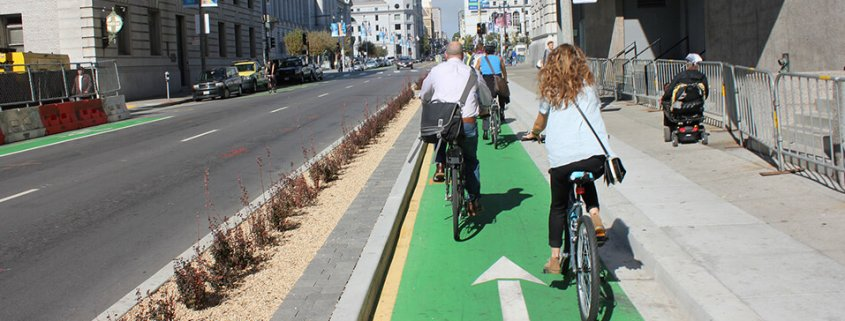
Example of a Class 4 bike lane. Image Source: Calbike.org
Community concerns were reinforced by collision data presented during the meeting. Between 2018 and 2023 “all injury collisions” in Auburn increased 140%, while “KSI” collisions—those involving fatalities or serious injuries—rose by 250%. Recent numbers also indicate that bicyclists and pedestrians account for approximately 44% of all traffic fatalities in the city.
Hananouchi explained that bicycle facility design depends heavily on roadway conditions, including traffic speed, vehicle volume, and available right-of-way. He noted that Highway 49 remains one of the most dangerous corridors in the region for crashes and bicyclist safety concerns, though much of the roadway falls under Caltrans jurisdiction.
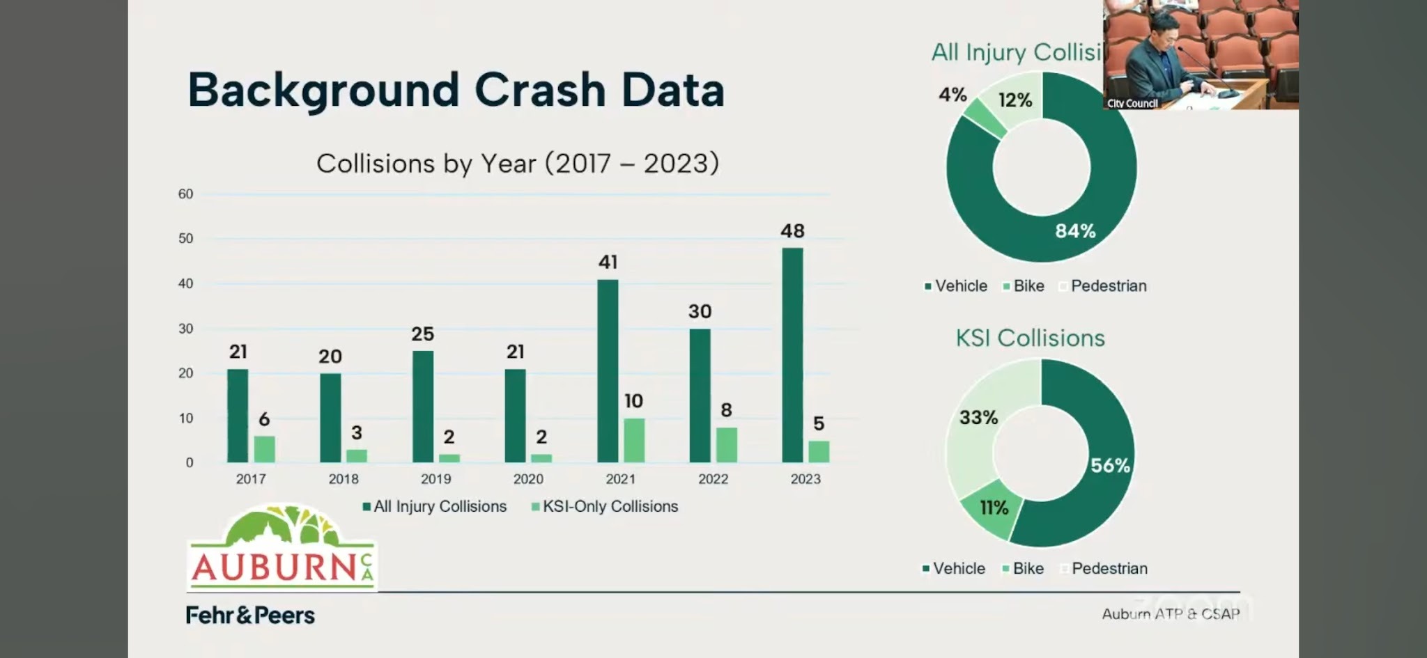
Image Source: Fehr & Peers, City of Auburn via YouTube.
That said, Hananouchi told the council, “We specifically identified locations that fall under the city’s jurisdiction.”
He also noted that roads with speeds above roughly 30 to 35 miles per hour generally warrant greater physical separation between cyclists and vehicle traffic under state and federal transportation design guidelines. However, Auburn’s steep terrain, narrow corridors, and existing built environment significantly limit where fully protected bike lanes can realistically be installed.
“The plan recommends more robust bicycle facilities to increase separation and improve comfort for riders,” Hananouchi said, adding that implementation could take “years, if not decades,” depending on funding availability and engineering constraints.
Officials also noted that in constrained corridors, including portions of Lincoln Way, the city may instead rely on painted bike lanes, shared roadway treatments, improved wayfinding signage, and lower-stress parallel routes where full separation is not feasible. In some locations, roadway reconfiguration could require difficult tradeoffs involving vehicle capacity, parking, and emergency access.
Some residents and council members raised concerns that physical barriers on steep downhill segments could reduce maneuverability during emergencies or collisions. Others cited maintenance costs, snow removal challenges, and the difficulty of retrofitting older roadways as additional concerns.
Despite differing views on how aggressively Auburn should pursue bicycle infrastructure expansion or e-bike programming, council members ultimately agreed that the ATP and CSAP provide an important long-term framework for future transportation planning.
City officials repeatedly emphasized that adoption of the plans does not approve any immediate construction projects. Any future infrastructure improvements will still require separate council approval, engineering review, environmental analysis, and identification of funding sources before implementation can begin.
To add to or correct any information in this report, please contact me at robert.m@lead4earth.org or leave a comment below with your thoughts.
1
0

Comments